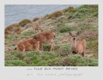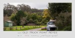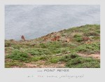
Category: Point Reyes National Seashore California
Point Reyes National Seashore California.
Separating the Point Reyes Peninsula from the mainland is a narrow linear valley running northwest-southeast incorporating the Bolinas Lagoon, Olema Valley, and Tomales Bay, the valley lies directly on the San Andres Fault, where the Pacific and North American continental plates meet. These plates are segments of Earth’s crust “floating” on a sea of molten rock. The Point Reyes peninsula rides on the eastern edge of the Pacific Plate, which advances northwestward. This is why Point Reyes’s rock don’t match those east of the fault zone, yet they match rocks hundreds of miles southeast. The average rate of movement of the Pacific Plate is only one or two inches a year. But the plates don’t always move freely relative to one another. The fault zone is actually many large and small faults running parallel and at odd angles. The plates can “catch” on each other, pressure builds up, and eventually the underlying rock breaks loose in a sudden jolt. This caused the 1906 San Francisco Earthquake, when the peninsula leapt 20 feet northwestward in less than a minute. It could happen again in 30 minutes or 300 years. The Earthquake Trail near Bear Valley Visitor Center shows you the results of Earth’s tremendous force………National Park Service U.S. Department of the Interior